


Trainsity Osaka
คำอธิบายของTrainsity Osaka
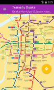
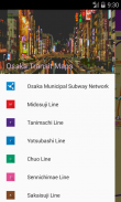
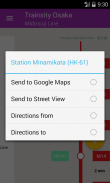
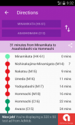
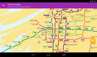
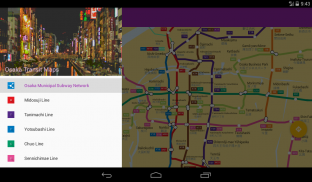
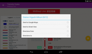
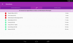
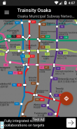
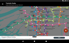
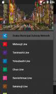
ค้นหาเส้นทางรอบสถานีรถไฟใต้ดินของเมืองโอซาก้าโดยใช้แผนที่เวกเตอร์ความละเอียดสูงของเครือข่ายรถไฟ มีบริการรถไฟใต้ดินต่อไปนี้: มิโดโซจิ, ทานิมาชิ, โยสึบาชิ, ชูโอ, เซนนิจิมาเอะ, ซาไกจิ, นากาฮาริ - ซึรุมิ - เรียวคุจิ, อิมาซาสึจิ, นิวทารามนังโกพอร์ต สาย Kitakyu Namboku แผนที่มีขนาดไฟล์เล็ก แต่มีการซูมหลายระดับและสามารถทำงานออฟไลน์ได้โดยไม่ต้องเชื่อมต่ออินเทอร์เน็ต ผู้ใช้สามารถคลิกที่ป้ายกล่องสถานีรถไฟเพื่อเปิด Google Maps หรือ Google StreetView ซึ่งพวกเขาสามารถใช้ฟังก์ชั่นทั้งหมดของแอพ Google เพื่อแสดงภาพพื้นที่โดยรอบและ / หรือดำเนินการหาเส้นทางสำหรับเส้นทาง นอกจากนี้ยังมีฟังก์ชั่นออฟไลน์เพื่อคำนวณวิธีที่ดีที่สุดในการเดินทางจากสถานีหนึ่งไปยังอีกสถานีหนึ่งที่มีการแบ่งทิศทางและการกำหนดเวลา (ซึ่งอาจแตกต่างจากเวลาเดินทางจริง)
* ขณะนี้ด้วยการตั้งค่าโหมดมืด
Trainsity Osaka - ข้อมูล APK
เวอร์ชั่น APK: 2.6.203แพ็คเกจ: com.dom925.trainsity.osakaเวอร์ชั่นล่าสุดของTrainsity Osaka
เวอร์ชั่นอื่น


 3.55
3.55

แอปในประเภทเดียวกัน

คุณอาจจะชอบ...


